
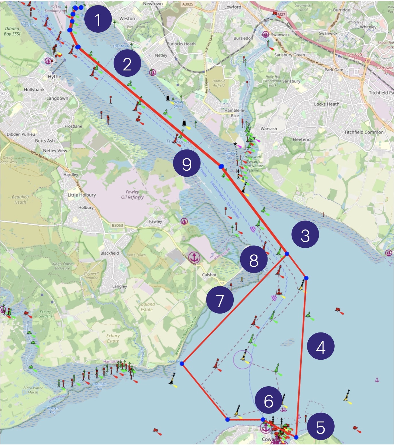
It’s a 20 mile daysail from SSC to Cowes and back, and is good for a low lunchtime neap tide.
For an 8am high tide, leave SSC at 10am, and because we have the ebb tide under us we are able to maintain 5 knots. Until we get to just off Cowes, the tide is with us.
Plan to be over the Bramble bank about noon to 13:00, and the ebb is beginning to slow. By 13:00, the tide is flooding up the sides of the channel and it’s mostly slack when we are on shore at East Cowes, by the Cafe and Public Toilets.
We have the tide with us for the return journey. If we leave at 2pm we should comfortably be ashore by 5pm, which is 3 hours before the next high.
What’s to see and do
Southampton Water is wide and interesting. You pass Weston, Netley Cliff and Netley Sailing Clubs, the oil refinery and moored ships and Calshot to then be presented with the large estuary area of the Solent, with views to both the East and West. There’s always a lot going on, including the movements of huge ships, ferries, fastjets, yacht races, dinghy races and more. Threading your way through this to visit the Isle of Wight is quite an adventure and you need to keep a very good lookout.
Calshot as a destination
If you are looking for a 10 mile round trip, a visit to Calshot is also a good location to aim for. In the very big building there is a cafe and toilets.
East Cowes as a destination
East Cowes is a quieter destination than attempting to get into Cowes (recommended only with an outboard or oars on a busy day. It is possible to sail up to Newport, but the winds inside Cowes are fluky and if it’s busy you need control of your vessel which the fluky winds may not facilitate.
East Cowes has a cafe and public toilet, which can be easily identified on approach. It’s a gently shelving beach. Near to low tide there is a cross current but it’s not much. There is a specific piece of beach which is frequented by UKSSA training groups because it’s next to a cafe and a public toilet, and it’s sandy.
Southampton Water
- Southampton water stretches for 6 miles and is well protected in all but strong SE winds
- All craft should heed the priority given to commercial traffic
- There is an area of concern between the entrance of Southampton Water and Cowes. Any vessel over 150m must be given a moving prohibited zone of 1000m ahead and 100m either side
- The turning point around West Bramble and Calshot Spit is particularly restricted
- Double HW occurs at Springs about 2 hrs apart, while at Neaps there is a long stand.
- MHWS: 4.5m; MHWN:3.7m; MLWN: 1.8m; MLWS: 0.5m
Shipping Lanes
We will be crossing the main shipping lanes, and as has been recently demonstrated and reported in the news, it’s very much best to not be run down by a big ship. We will have rendezvous points before we cross each shipping lane and we will cross at 90 degrees as a fleet when we can see that it is clear to do so.
We cross the deep water channel four times; once at Calshot as we cross the deep water channel which runs across the north of the Solent, then between the Bramble Bank and the IOW, once South to North across the less used Western Passage from Gurnerd to North of Lepe, and then finally back to the North side of Southampton Water at Calshot. All crossing locations have good visibility.
Dinghy Trail Guidance
- Leave SSC about 2 hours after high water.
- Stick to the north side of the channel and do not sail in the main shipping lanes. This is simply a precaution – if something were to go wrong; capsize, MOB, sudden drop in wind strength, you can have your difficulty without the added pressure of an oncoming ferry, fastcat or huge ship.
- At the turn at Calshot, make your turn wide and stay out of the shipping lane.
- Visit Bramblemet and behold the industrial architecture. Then keep a very good lookout for ferries, fastjets and shipping as you cross the shipping lane heading for East Cowes and land on the sandy beach by the Cafe and public loos. Note that there’s a lovely google map of the location, including some dinghies at the recommended landing place and the cafe https://maps.app.goo.gl/KytTmUQD1Q3wpvrr9
- Enjoy lunch until the tide is about to turn or only just turns – you will be sailing into a flood tide for the first half mile of the return journey.
- You are crossing the front of Cowes, which is tremendously congested so keep a very good lookout. Pass beyond the North Cardinal at Gurnard to the prominent port hand mark to your North-West. This is a less well used route to and from Southampton Port but it is used so do not assume where a ship may be going. You are avoiding but skirting the turning area for ships using the Eastern Solent so only leave the shore if no large ships are about.
- Keep out of the shipping lane, but stay close to the port hand marks near Calshot as there are extensive shallow waters off Calshot Spit.
- Keep a lookout again, you are crossing the main shipping lane from South to North and have good visibility as you are crossing it at the corner. If clear, pass directly across at 90 degrees to the lane.
- Stay north of the Starboard Hand marks and out of the shipping lane back to SSC.
We sailed this is a F5 SW, and as we turned South at Calshot we reefed as the full strength of the very steady F5 was experienced, and we reefed on the water. The ebb tide, combined with the wind from the SW were mostly 2m there were several that were 3m, and too big for sailing in boats of our size. We turned back to Calshot and lunched there. We have sailed this in a F3-4 and the waves were not an issue.